 Barcode:
1000291
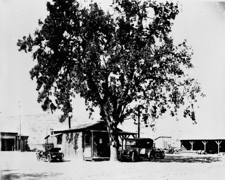
Field headquarters at Fairmont Reservoir Subjects:
Trees
Buildings
Automobiles
Collection: Bledsoe Collection 1908-1933
|
Barcode: 1000291 |
Title: Fairmont Reservoir
Description: Field headquarters at Fairmont Reservoir Subjects: Trees Buildings Automobiles Collection: Bledsoe Collection 1908-1933 |
 Barcode:
1000478 |
Title: Owens Valley Power Plants
Description: Big Pine Power Plant 3 September, 1925 – “This is an ideal location for the Upper Plant; right over there we can located the intake for Plant No. 2 which will be farther down the canyon and that will locate Plant No. 3 in the delta just below the mouth of the canyon.” They were talking about the proper development of Big Pine Creek. The time was the summer of 1911. They were camped at the Forks of Big Pine Creek on the steep eastern slopes of the High Sierras. Above them towered the Sierras peaks 14,000 feet high – just below the crests were the snow and ice packs that give this section its renown for everlasting glaciers and constant water flow. The vision which prompted their decision was no doubt fathered by the realization that there was a close relationship between those towering peaks, the valley below, and the City of the Angels, 275 miles to the southward. Their vision included not only the proper development of power but the maximum use of the waters of the stream on the farms below; and their constant efforts and negotiations finally resulted in an agreement between the City and the Big Bear Water Users’ Association. An agreement of mutual benefit. The City was given the right to store water, provided it built the dams, and a schedule of water flow for each month was agreed upon. Built Dam at Lake No. 3 During the summer of 1921 a dam was partly built at Lake No. 2 and certain required storage thereby provided. The portion of the road built this summer of 1925, during the construction of Big Pine No. 3, looks forward to the ultimate raising of the level of the lakes and at the same time make that wonderful country accessible to the motorist. Big Pine No. 3 is now a reality. The mountains and the City have come closer together as a result of the completion of this project. This hydro-electric power is now flowing to the homes, farms and commercial centers of Owens Valley, where it renders a t cheap rates a service that is indispensable. More than that, – this power is adding in a big way to the water conservation and water development of Owens Valley directly – and the City of Los Angeles indirectly. It is the largest of six power plants on the 200-mile electric system which the City of Los Angeles owns and operates in Owens Valley. It is of especial interest that just at the time the plant was nearing completion, Mother Nature, through the vagaries of some record breaking storms, seriously crippled the Southern Sierras Power Company’s equipment that supplies some large chemical industries in the Valley, and through temporary connections Big Pine No. 3 Power Plant was able to step into the threatened power shortage and tide the Power Company over until repairs could be made. Big Pine No. 3 Power Plant is equipped with a 4,000-horsepower Pelton Water Wheel and a 4,000 K.V.A General Electric Generator which feeds into the 33,000-volt valley electric system of the Water Department through an outdoor step-up transformer station. Every possible provision has been made for the safety of men and equipment. In this power plant, whose intake is nearly a mile and a half above sea level, lightning is a nightly and almost daily visitor. The possibility of damage or interruption from this source was given special thought by the installation of the newest type of Auto Valve Lightning Arresters of the outdoor type. As much of the equipment as possible was installed outdoors and presents a pleasing part of the entire power plant setting. The building is of simple yet attractive design, reinforced concrete and fireproof in its construction, and withal it reflects credit to that first conception of location as well as to the more recent details of its construction. From the diversion dam or intake on the creek far up in the canyon, through the fish trap and the long pre-cast concrete flow line, to the steel penstock where the water shoots down more than 1,200 feet to the Power Plant, one can see every kind of difficult construction problem that can be imagined. This more then two miles of flow line and penstock was carved out of the steep mountain side under extreme difficulties. Careful preparation of construction equipment and the necessary provisions for making repairs or alterations in the field are largely responsible for the excellent showing made in completing the entire construction program within the scheduled time estimated. Too much credit cannot be given to the field forces for combating the various and sundry difficulties which are always present upon construction work. In this case, it was a race against time with the base of supplies 275 miles away and the fact added to the individual responsibilities of the men on the job. It is also to their credit that much of the work was done for less money than estimated and in some instances represented large savings over a contractor’s bid for doing the same work. At times, more than 200 men were employed, and the health of the various camps was 100 per cent, which speaks well for the cooks and the camp supervision. In carrying on the construction activities, every opportunity was given for the employment of Owens Valley residents and the few who went up from the city of Los Angeles were outspoken in their commendation of the interest displayed and the cordial treatment they received from their newly made friends in the Big Pine section. Many miles of excellent roads were built by the Department before the actual power plant construction could be started. These roads are already carrying a constantly increasing travel of autos into the glacier country at the head of Big Pine Creek. Big trees, waterfalls, beautiful lakes and permanent glaciers offer opportunity for fishing and sight-seeing which is unsurpassed in the West. The time is sure to come when this magnificent mountain country will be on the regular schedule of the traveling and camping public and when it does come, the Department of Water and Power will be given due credit for the constructive vision of its engineers in conserving and utilizing to best advantage so large a part of the natural resources on the Eastern Slope of the Sierra Nevada Mountains. Millions upon million of dollars is being spent in constructive activities in Owens Valley by the City of Los Angeles. The program of development is but started. “Rome was not built in a day.” The West was not won in a year nor a generation. As time goes by, and the far seeing vision of our leaders becomes reality, as has Big Pine No. 3, this southwest empire, from the High Sierras to the Pacific, will be one and the same family in thought, purpose and action. Subjects: Buildings Automobiles Electrical Apparatus Collection: Bledsoe Collection 1908-1933 |
 Barcode:
1000479 |
Title: Owens Valley Power Plants
Description: Big Pine Power Plant 3 September, 1925 – “This is an ideal location for the Upper Plant; right over there we can located the intake for Plant No. 2 which will be farther down the canyon and that will locate Plant No. 3 in the delta just below the mouth of the canyon.” They were talking about the proper development of Big Pine Creek. The time was the summer of 1911. They were camped at the Forks of Big Pine Creek on the steep eastern slopes of the High Sierras. Above them towered the Sierras peaks 14,000 feet high – just below the crests were the snow and ice packs that give this section its renown for everlasting glaciers and constant water flow. The vision which prompted their decision was no doubt fathered by the realization that there was a close relationship between those towering peaks, the valley below, and the City of the Angels, 275 miles to the southward. Their vision included not only the proper development of power but the maximum use of the waters of the stream on the farms below; and their constant efforts and negotiations finally resulted in an agreement between the City and the Big Bear Water Users’ Association. An agreement of mutual benefit. The City was given the right to store water, provided it built the dams, and a schedule of water flow for each month was agreed upon. Built Dam at Lake No. 3 During the summer of 1921 a dam was partly built at Lake No. 2 and certain required storage thereby provided. The portion of the road built this summer of 1925, during the construction of Big Pine No. 3, looks forward to the ultimate raising of the level of the lakes and at the same time make that wonderful country accessible to the motorist. Big Pine No. 3 is now a reality. The mountains and the City have come closer together as a result of the completion of this project. This hydro-electric power is now flowing to the homes, farms and commercial centers of Owens Valley, where it renders a t cheap rates a service that is indispensable. More than that, – this power is adding in a big way to the water conservation and water development of Owens Valley directly – and the City of Los Angeles indirectly. It is the largest of six power plants on the 200-mile electric system which the City of Los Angeles owns and operates in Owens Valley. It is of especial interest that just at the time the plant was nearing completion, Mother Nature, through the vagaries of some record breaking storms, seriously crippled the Southern Sierras Power Company’s equipment that supplies some large chemical industries in the Valley, and through temporary connections Big Pine No. 3 Power Plant was able to step into the threatened power shortage and tide the Power Company over until repairs could be made. Big Pine No. 3 Power Plant is equipped with a 4,000-horsepower Pelton Water Wheel and a 4,000 K.V.A General Electric Generator which feeds into the 33,000-volt valley electric system of the Water Department through an outdoor step-up transformer station. Every possible provision has been made for the safety of men and equipment. In this power plant, whose intake is nearly a mile and a half above sea level, lightning is a nightly and almost daily visitor. The possibility of damage or interruption from this source was given special thought by the installation of the newest type of Auto Valve Lightning Arresters of the outdoor type. As much of the equipment as possible was installed outdoors and presents a pleasing part of the entire power plant setting. The building is of simple yet attractive design, reinforced concrete and fireproof in its construction, and withal it reflects credit to that first conception of location as well as to the more recent details of its construction. From the diversion dam or intake on the creek far up in the canyon, through the fish trap and the long pre-cast concrete flow line, to the steel penstock where the water shoots down more than 1,200 feet to the Power Plant, one can see every kind of difficult construction problem that can be imagined. This more then two miles of flow line and penstock was carved out of the steep mountain side under extreme difficulties. Careful preparation of construction equipment and the necessary provisions for making repairs or alterations in the field are largely responsible for the excellent showing made in completing the entire construction program within the scheduled time estimated. Too much credit cannot be given to the field forces for combating the various and sundry difficulties which are always present upon construction work. In this case, it was a race against time with the base of supplies 275 miles away and the fact added to the individual responsibilities of the men on the job. It is also to their credit that much of the work was done for less money than estimated and in some instances represented large savings over a contractor’s bid for doing the same work. At times, more than 200 men were employed, and the health of the various camps was 100 per cent, which speaks well for the cooks and the camp supervision. In carrying on the construction activities, every opportunity was given for the employment of Owens Valley residents and the few who went up from the city of Los Angeles were outspoken in their commendation of the interest displayed and the cordial treatment they received from their newly made friends in the Big Pine section. Many miles of excellent roads were built by the Department before the actual power plant construction could be started. These roads are already carrying a constantly increasing travel of autos into the glacier country at the head of Big Pine Creek. Big trees, waterfalls, beautiful lakes and permanent glaciers offer opportunity for fishing and sight-seeing which is unsurpassed in the West. The time is sure to come when this magnificent mountain country will be on the regular schedule of the traveling and camping public and when it does come, the Department of Water and Power will be given due credit for the constructive vision of its engineers in conserving and utilizing to best advantage so large a part of the natural resources on the Eastern Slope of the Sierra Nevada Mountains. Millions upon million of dollars is being spent in constructive activities in Owens Valley by the City of Los Angeles. The program of development is but started. “Rome was not built in a day.” The West was not won in a year nor a generation. As time goes by, and the far seeing vision of our leaders becomes reality, as has Big Pine No. 3, this southwest empire, from the High Sierras to the Pacific, will be one and the same family in thought, purpose and action. Subjects: Buildings Automobiles Electrical Apparatus Collection: Bledsoe Collection 1908-1933 |
 Barcode:
1000613 |
Title: Towns in Owens Valley
Description: Street scene, Bishop California - The first white American explores in the Owens Valley of Eastern California included the famous mountain men Jedediah Smith in 1826 and Joseph Walker in 1834. This remote area of California had never been explored by the Spanish and even though it was shown as Mexican territory on early maps, the Eastern Sierra region remained unvisited by them. Present day Walker Lake in western Nevada, the Walker River on the California /Nevada border and Walker Pass in the southern Sierra were named for their discovered, Joseph Walker. The most renowned early explorer to visit the area was John C. Fremont. He was the first Republican candidate to run for President of the United States in 1856 and later a famous Union Civil War General. Officially sanctioned by the federal government, his 1845 mapping party to the Eastern Sierra included the celebrated Indian scout Kit Carson, for whom the capital of Nevada, Carson City, was named. Also in the party were Ed Kern for whom Kern County, California was named, and Richard Owens, who gave his name to the Owens Lake near Lone Pine and later the Owens Valley itself. Fremont lost a cannon that he had brought along in case of Indian attacks somewhere near present day Bridgeport, California (about 80 miles north of Bishop). Perhaps someone will stumble across the rusty old cannon someday. The city of Bishop came into being due to the need for beef in a booming mining camp some eighty miles to the north, Aurora, Nevada, (Aurora was believed to be on the other side of the border at that time and was the county seat of Mono County, California). In 1861 cattlemen drove herds of cattle some three hundred miles from the great San Joaquin Valley of California, through the southern Sierra at Walker Pass up the Owens Valley, and then through Adobe Meadows to Aurora. Along the way, some cattlemen noticed that the unsettled northern Owens Valley was perfect for raising livestock. To avoid the long journey from the other side of the mountains, a few of them decided to settle in the valley. Driving some 600 head of cattle and 50 horses, Samuel Addison Bishop, his wife, and several hired hands arrived in the Owens Valley on August 22, 1861 from Fort Tejón in the Tehachapi Mountains. Along with Henry Vansickle, Charles Putnam, Allen Van Fleet, and the McGee brothers, Bishop was one of the very first white settlers in the valley. Samuel Bishop made his camp at a location a short distance west and south of the present city of Bishop and later built a house at that location. He named his holdings the “San Francis Ranch.” He was a Virginian born in 1825; a California Forty-Niner judge at Fort Tejón; and partner of General Beale in the cattle business. His residence in Bishop was a comparatively short duration and his closing years were spent in San Jose. Bishop Creek is also named after him. The cattlemen were soon followed by sheep men who initially struggled with a lack of forage for their stock in the area. Remnants of those early settler’s stone corrals and fences can still be seen north of Bishop along Highway 395 in Round Valley (barb wire fencing was not invented until 1873). Subjects: Roads Automobiles Men Buildings Power Lines Collection: Bledsoe Collection 1908-1933 |
 Barcode:
1000614 |
Title: Towns in Owens Valley
Description: Typical business street in Bishop, California, one of five towns included in water purchase plan - The first white American explores in the Owens Valley of Eastern California included the famous mountain men Jedediah Smith in 1826 and Joseph Walker in 1834. This remote area of California had never been explored by the Spanish and even though it was shown as Mexican territory on early maps, the Eastern Sierra region remained unvisited by them. Present day Walker Lake in western Nevada, the Walker River on the California /Nevada border and Walker Pass in the southern Sierra were named for their discovered, Joseph Walker. The most renowned early explorer to visit the area was John C. Fremont. He was the first Republican candidate to run for President of the United States in 1856 and later a famous Union Civil War General. Officially sanctioned by the federal government, his 1845 mapping party to the Eastern Sierra included the celebrated Indian scout Kit Carson, for whom the capital of Nevada, Carson City, was named. Also in the party were Ed Kern for whom Kern County, California was named, and Richard Owens, who gave his name to the Owens Lake near Lone Pine and later the Owens Valley itself. Fremont lost a cannon that he had brought along in case of Indian attacks somewhere near present day Bridgeport, California (about 80 miles north of Bishop). Perhaps someone will stumble across the rusty old cannon someday. The city of Bishop came into being due to the need for beef in a booming mining camp some eighty miles to the north, Aurora, Nevada, (Aurora was believed to be on the other side of the border at that time and was the county seat of Mono County, California). In 1861 cattlemen drove herds of cattle some three hundred miles from the great San Joaquin Valley of California, through the southern Sierra at Walker Pass up the Owens Valley, and then through Adobe Meadows to Aurora. Along the way, some cattlemen noticed that the unsettled northern Owens Valley was perfect for raising livestock. To avoid the long journey from the other side of the mountains, a few of them decided to settle in the valley. Driving some 600 head of cattle and 50 horses, Samuel Addison Bishop, his wife, and several hired hands arrived in the Owens Valley on August 22, 1861 from Fort Tejón in the Tehachapi Mountains. Along with Henry Vansickle, Charles Putnam, Allen Van Fleet, and the McGee brothers, Bishop was one of the very first white settlers in the valley. Samuel Bishop made his camp at a location a short distance west and south of the present city of Bishop and later built a house at that location. He named his holdings the “San Francis Ranch.” He was a Virginian born in 1825; a California Forty-Niner judge at Fort Tejón; and partner of General Beale in the cattle business. His residence in Bishop was a comparatively short duration and his closing years were spent in San Jose. Bishop Creek is also named after him. The cattlemen were soon followed by sheep men who initially struggled with a lack of forage for their stock in the area. Remnants of those early settler’s stone corrals and fences can still be seen north of Bishop along Highway 395 in Round Valley (barb wire fencing was not invented until 1873). Subjects: Buildings Automobiles Roads Collection: Bledsoe Collection 1908-1933 |
 Barcode:
1000632 |
Title: Early City Views
Photo Date: early 1900's Description:Street scene, Broadway The Los Angeles coastal area was first settled by the Tongva (or Gabrieleños) and Chumash Native American tribes thousands of years ago. The first Europeans arrived in 1542 under João Cabrilho, a Portuguese explorer who claimed the area as the City of God for the Spanish Empire but continued with his voyage and did not establish a settlement. The next contact would not come until 227 years later when Gaspar de Portola, together with Franciscan missionary Juan Crespi, reached the present site of Los Angeles on August 2, 1769. Crespi noted that the site had the potential to be developed into a large settlement. In 1771, Franciscan friar Junipero Serra built the Mission San Gabriel Arcangel near Whittier Narrows, in what is now called San Gabriel Valley. In 1777, the new governor of California, Felipe de Neve, recommended to the viceroy of New Spain that the site recommended by Juan Crespi be developed into a pueblo. The town was founded on September 4, 1781 by a group of 44 settlers and was named "El Pueblo de Nuestra Señora la Reina de los Ángeles del Río de Porciúncula," ("The Town of Our Lady the Queen of the Angels on the River Porciúncula"). These settlers were of Filipino, Native American, African, and Spanish ancestry, with two-thirds being mestizo or mulatto. A majority of the settlers had some African ancestry. The settlement remained a small ranch town for decades, but by 1820 the population had increased to about 650 residents. Today, the pueblo is commemorated in the historic district Olvera Street, the oldest part of Los Angeles New Spain achieved its independence from the Spanish Empire in 1821, and the pueblo continued as a part of Mexico. Mexican rule ended during the Mexican-American War, when Americans took control from the Californios after a series of battles, culminating in the signing of the Treaty of Cahuenga on January 13, 1847. Later, with the Treaty of Guadalupe Hidalgo in 1848, the Mexican government formally ceded Alta California and other territories to the United States. Railroads arrived when the Southern Pacific completed its line to Los Angeles in 1876 Oil was discovered in 1892, and by 1923 Los Angeles was producing one-quarter of the world's petroleum. By 1900, the population had grown to more than 100,000 people, which began to put pressure on the city's water supply. The 1913 completion of the Los Angeles aqueduct under the supervision of William Mulholland, assured the continued growth of the city. In 1915, Los Angeles began annexation of dozens of neighboring communities without water supplies of their own. Subjects: People Automobiles Roads Buildings Sidewalks Collection: Bledsoe Collection 1908-1933 |
 Barcode:
1000715 |
Title: San Fernando Reservoir
Description: Lower San Fernando Reservoir construction January 1930 – In line with plans for increasing the storage capacity of reservoirs near Los Angeles, the Bureau of Water Works and Supply is carrying forward two major projects at lower San Fernando and Chatsworth. Work has started and it’s progressing satisfactorily on the enlargement of the Lower San Fernando Reservoir. The capacity will be increased from 14,000 to 18,000-acre feet by raising the height of the earth fill dam there 12 feet. The dam is 2,400 feet long. State Engineer Edward Hyatt issued a permit several weeks ago for the enlargement work. The project, it is estimated, will cost $265,000, to be paid out of water revenues. The enlargement will be completed within six months, according to H. A. Van Norman, general manager and chief engineer of the Bureau of Water Works and Supply. As another means of increasing storage basin capacity, the Bureau is proceeding with plans for increasing the capacity of the Chatsworth reservoir. If a high dam is selected, the capacity of the reservoir will be in creased from 9000 to 40,000-acre feet. Plans for work on this dam, however, are still in a preliminary stage. Engineers estimate that the total storage need in close proximity to Los Angeles is about 60,000-acre feet. If Chatsworth enlargement is carried through to bring an increase to 40,000-acre feet, this added to the Lower San Fernando increase will give the city approximately 35,000-arce feet additional to the nearby storage basins. The Palisades Reservoir, completed at a cost of $140,000 was officially put into service November 20, 1929, with a capacity of 7,000,000 gallons, this Westgate area stretching from Westgate to the Palisades. It is both a regulating and a storage reservoir. Water flows into it from Stone Canyon Reservoir. The Palisades Reservoir is located in Rustic Canyon, and required eight months to build. Subjects: Water Hills Roads Automobiles Collection: Padilla Collection 1908-1935 |
 Barcode:
1000921 |
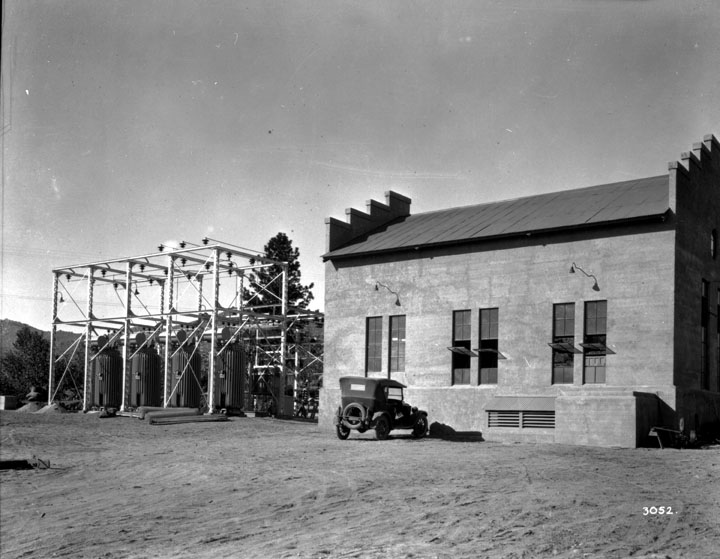
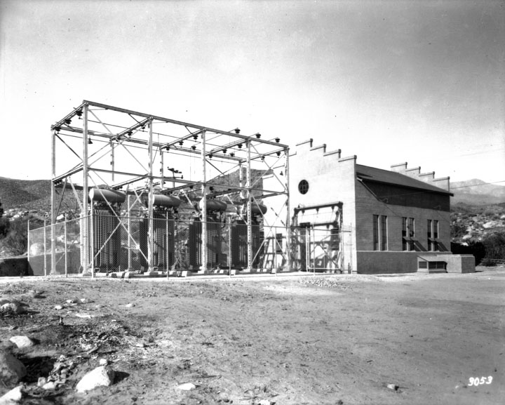
Title: San Francisquito Power Plant No. 2
Description: San Francisquito Power Plant No. 2 Subjects: Buildings Hills Pipes Roads Automobiles Collection: Padilla Collection 1908-1935 |
 Barcode:
1000938 |
Title: Alameda Steam Plant
Description: Alameda Steam Plant Subjects: Buildings Railroad Tracks Automobiles Power Lines Roads Collection: Padilla Collection 1908-1935 |
 Barcode:
1000940 |
Title: Alameda Steam Plant
Description: Cooling towers, Alameda Steam Plant Subjects: Buildings Roads Automobiles Collection: Padilla Collection 1908-1935 |