 Barcode:
1000016
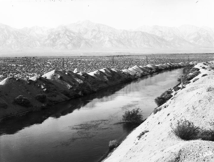
Open unlined section of Los Angeles Aqueduct Subjects:
Water
Mountains
Deserts
Collection: Bledsoe Collection 1908-1933
|
Barcode: 1000016 |
Title: Aqueduct Construction
Description: Open unlined section of Los Angeles Aqueduct Subjects: Water Mountains Deserts Collection: Bledsoe Collection 1908-1933 |
 Barcode:
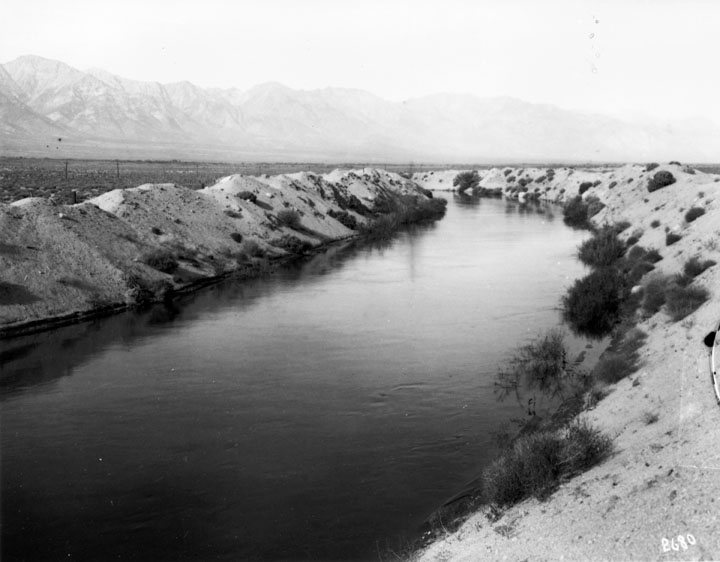
1000017 |
Title: Aqueduct Construction
Description: Open unlined section of Los Angeles Aqueduct Subjects: Water Mountains Deserts Collection: Bledsoe Collection 1908-1933 |
 Barcode:
1000071 |
Title: Crews and Camps During Aqueduct Construction
Description: O. W. Peterson Camp at Lone Pine - – Named after a solitary pine tree that once stood at the mouth of Lone Pine Canyon, this small California town's roots stretch back into the Old West -- and Hollywood's Wild West, too. Back in the mid-1800's, the town of Lone Pine was founded to supply local miners with provisions. Farmer and ranchers followed soon after, and after that, the Carson Colorado Railroad pulled into town. Today, the only part of pre-1870 Lone Pine that's still standing is a portion of an old adobe wall that stands behind the local flower store, "La Florista". A few miles to the east, you can also wander among the decaying ghost-town ruins of Cerro Gordo. The town is located in the Owens Valley, near the Alabama Hills. On March 26, 1872 a very large earthquake destroyed most of the town and killed 27 of its 250-300 residents. Much of the local economy is based on tourism, as the town is between several major tourist destinations, such as Mount Whitney, Sequoia National Park, Kings Canyon National Park, Mammoth Mountain, Death Valley National Park, and Yosemite National Park; many motels line the main road through town. The Manzanar National Historic Site (formerly the Manzanar War Relocation Center), a Japanese American internment camp (concentration camp) during World War II, is located on Highway 395 north of Lone Pine and south of Independence. Manzanar (which means “apple orchard” in Spanish) is the best-known of the ten camps in which Japanese Americans, both citizens (including natural-born Americans) and resident aliens, were imprisoned during World War II. Manzanar has been identified as the best preserved of these camps by the Untied States National Park Service which maintains and is restoring the site as a U.S. National Historic Site. The Alabama Hills Recreation Area are located just west of town, on the road to the Whitney Portal which offers access to Mount Whitney. On the way to Whitney Portals and the Alabama Hills visitors will pass over the two Los Angeles Aqueducts, the First Los Angeles Aqueduct (completed 1913) and the Second Los Angeles Aqueduct (completed 1970). These aqueducts traditionally have supplied Los Angeles with about half its water, some 450,000 acre feet (560,000,000 m³) a year. Because groundwater pumping continues at a higher rate than the rate at which water recharges the aquifer, the result is a lone-term trend of desertification in the Owens Valley. The Sierra Nevada range and the Inyo Mountains dominate the views from the town. The picturesque Alabama Hills lie to the west of Lone Pine. Their unique appearance has attracted many film companies over the years to Lone Pine for filming westerns. The hills were named in 1862 by Southern sympathizers commemorating the victories of the Confederate ship Alabama. The Lone Pine Indian Reservation is home to persons of Paiute, and Shoshone lineage and is a Federally recognized tribe. The tribe is the most southern band of Northern Paiutes who were sedentary to the valley due to the suitable climate and abundant food supply. These people have been living here for several thousands of years. The reservation is along the south side of town on both sides of US395. Subjects: Mountains Buildings Collection: Bledsoe Collection 1908-1933 |
 Barcode:
1000050 |
Title: Aqueduct Construction
Description: Dipper dredge working in main canal, Owens Valley Division Subjects: Excavation Water Mountains Steam Shovels Collection: Bledsoe Collection 1908-1933 |
 Barcode:
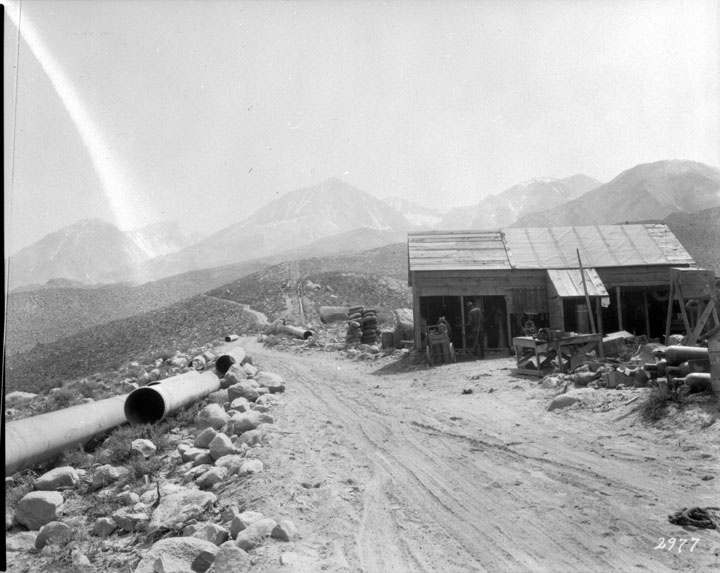
1000064 |
Title: Methods of Transporting Materials and Men During Construction on Aqueduct
Description: Mule buggy team Subjects: Mules Mountains Deserts Collection: Bledsoe Collection 1908-1933 |
 Barcode:
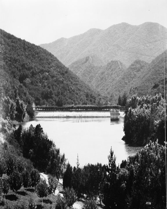
1000300 |
Title: Franklin Canyon Reservoir
Description: Upper Franklin Reservoir – located at Franklin Canyon Drive south of Mulholland Drive at Coldwater Canyon, Beverly Hills, it holds 38.572 million gallons of water it went into service February 1915 and went out of service in December 1982 Subjects: Mountains Water Trees Collection: Bledsoe Collection 1908-1933 |
 Barcode:
1000337 |
Title: Owens Valley Power Plants and Owens River Gorge
Description: Camp No. 5 at Owens River Gorge The Owens River Gorge is a steep 10 miles (16 km) canyon on the upper Owens River in eastern California. The canyon is located at the eastern edge of the Sierra Nevada Mountains in southern Mono County, along the stretch of the river where it exits the Long Valley near its source and enters the north end of Owens Valley. The gorge is a popular destination for rock climbing. The Owens River Gorge was formed when the Owens River cut through the Bishop Tuff: a layer of welded ash formed from the eruption of the long Valley Caldera. This erosion exposed the tuff layers, including rare columnar rhyolite formations. The Los Angeles Department of Water and Power constructed the Long Valley Dam at the head of the Owens River Gorge as part of a hydropower project in 1941, and completely dewatered the 16-km Lower Gorge reach from 1953 to 1991. Beginning in 1991, a limited range of flows has been released to re-water the reach, recreate riparian habitat, and re-establish a brown trout sport fishery while maintaining hydropower diversions. Subjects: Canyons Mountains Buildings Collection: Bledsoe Collection 1908-1933 |
 Barcode:
1000341 |
Title: Owens Valley Power Plants and Owens River Gorge
Description: Owens River Gorge The Owens River Gorge is a steep 10 miles (16 km) canyon on the upper Owens River in eastern California. The canyon is located at the eastern edge of the Sierra Nevada Mountains in southern Mono County, along the stretch of the river where it exits the Long Valley near its source and enters the north end of Owens Valley. The gorge is a popular destination for rock climbing. The Owens River Gorge was formed when the Owens River cut through the Bishop Tuff: a layer of welded ash formed from the eruption of the long Valley Caldera. This erosion exposed the tuff layers, including rare columnar rhyolite formations. The Los Angeles Department of Water and Power constructed the Long Valley Dam at the head of the Owens River Gorge as part of a hydropower project in 1941, and completely dewatered the 16-km Lower Gorge reach from 1953 to 1991. Beginning in 1991, a limited range of flows has been released to re-water the reach, recreate riparian habitat, and re-establish a brown trout sport fishery while maintaining hydropower diversions. Subjects: Canyons Water Mountains Collection: Bledsoe Collection 1908-1933 |
 Barcode:
1000474 |
Title: Owens Valley Power Plant
Description: Construction of Big Pine Power Plant Subjects: Construction Mountains Collection: Bledsoe Collection 1908-1933 |
 Barcode:
1000475 |
Title: Owens Valley Power Plants
Description: Big Pine Power Plant 3 September, 1925 – “This is an ideal location for the Upper Plant; right over there we can located the intake for Plant No. 2 which will be farther down the canyon and that will locate Plant No. 3 in the delta just below the mouth of the canyon.” They were talking about the proper development of Big Pine Creek. The time was the summer of 1911. They were camped at the Forks of Big Pine Creek on the steep eastern slopes of the High Sierras. Above them towered the Sierras peaks 14,000 feet high – just below the crests were the snow and ice packs that give this section its renown for everlasting glaciers and constant water flow. The vision which prompted their decision was no doubt fathered by the realization that there was a close relationship between those towering peaks, the valley below, and the City of the Angels, 275 miles to the southward. Their vision included not only the proper development of power but the maximum use of the waters of the stream on the farms below; and their constant efforts and negotiations finally resulted in an agreement between the City and the Big Bear Water Users’ Association. An agreement of mutual benefit. The City was given the right to store water, provided it built the dams, and a schedule of water flow for each month was agreed upon. Built Dam at Lake No. 3 During the summer of 1921 a dam was partly built at Lake No. 2 and certain required storage thereby provided. The portion of the road built this summer of 1925, during the construction of Big Pine No. 3, looks forward to the ultimate raising of the level of the lakes and at the same time make that wonderful country accessible to the motorist. Big Pine No. 3 is now a reality. The mountains and the City have come closer together as a result of the completion of this project. This hydro-electric power is now flowing to the homes, farms and commercial centers of Owens Valley, where it renders a t cheap rates a service that is indispensable. More than that, – this power is adding in a big way to the water conservation and water development of Owens Valley directly – and the City of Los Angeles indirectly. It is the largest of six power plants on the 200-mile electric system which the City of Los Angeles owns and operates in Owens Valley. It is of especial interest that just at the time the plant was nearing completion, Mother Nature, through the vagaries of some record breaking storms, seriously crippled the Southern Sierras Power Company’s equipment that supplies some large chemical industries in the Valley, and through temporary connections Big Pine No. 3 Power Plant was able to step into the threatened power shortage and tide the Power Company over until repairs could be made. Big Pine No. 3 Power Plant is equipped with a 4,000-horsepower Pelton Water Wheel and a 4,000 K.V.A General Electric Generator which feeds into the 33,000-volt valley electric system of the Water Department through an outdoor step-up transformer station. Every possible provision has been made for the safety of men and equipment. In this power plant, whose intake is nearly a mile and a half above sea level, lightning is a nightly and almost daily visitor. The possibility of damage or interruption from this source was given special thought by the installation of the newest type of Auto Valve Lightning Arresters of the outdoor type. As much of the equipment as possible was installed outdoors and presents a pleasing part of the entire power plant setting. The building is of simple yet attractive design, reinforced concrete and fireproof in its construction, and withal it reflects credit to that first conception of location as well as to the more recent details of its construction. From the diversion dam or intake on the creek far up in the canyon, through the fish trap and the long pre-cast concrete flow line, to the steel penstock where the water shoots down more than 1,200 feet to the Power Plant, one can see every kind of difficult construction problem that can be imagined. This more then two miles of flow line and penstock was carved out of the steep mountain side under extreme difficulties. Careful preparation of construction equipment and the necessary provisions for making repairs or alterations in the field are largely responsible for the excellent showing made in completing the entire construction program within the scheduled time estimated. Too much credit cannot be given to the field forces for combating the various and sundry difficulties which are always present upon construction work. In this case, it was a race against time with the base of supplies 275 miles away and the fact added to the individual responsibilities of the men on the job. It is also to their credit that much of the work was done for less money than estimated and in some instances represented large savings over a contractor’s bid for doing the same work. At times, more than 200 men were employed, and the health of the various camps was 100 per cent, which speaks well for the cooks and the camp supervision. In carrying on the construction activities, every opportunity was given for the employment of Owens Valley residents and the few who went up from the city of Los Angeles were outspoken in their commendation of the interest displayed and the cordial treatment they received from their newly made friends in the Big Pine section. Many miles of excellent roads were built by the Department before the actual power plant construction could be started. These roads are already carrying a constantly increasing travel of autos into the glacier country at the head of Big Pine Creek. Big trees, waterfalls, beautiful lakes and permanent glaciers offer opportunity for fishing and sight-seeing which is unsurpassed in the West. The time is sure to come when this magnificent mountain country will be on the regular schedule of the traveling and camping public and when it does come, the Department of Water and Power will be given due credit for the constructive vision of its engineers in conserving and utilizing to best advantage so large a part of the natural resources on the Eastern Slope of the Sierra Nevada Mountains. Millions upon million of dollars is being spent in constructive activities in Owens Valley by the City of Los Angeles. The program of development is but started. “Rome was not built in a day.” The West was not won in a year nor a generation. As time goes by, and the far seeing vision of our leaders becomes reality, as has Big Pine No. 3, this southwest empire, from the High Sierras to the Pacific, will be one and the same family in thought, purpose and action. Subjects: Mountains Pipes Buildings Roads Collection: Bledsoe Collection 1908-1933 |