Barcode:
1000307
Pumping plant Subjects:
Roads
Buildings
Power Lines
Collection: Bledsoe Collection 1908-1933
|
Barcode: 1000307 |
Title: Pumping Plant
Description: Pumping plant Subjects: Roads Buildings Power Lines Collection: Bledsoe Collection 1908-1933 |
 Barcode:
1000320 |
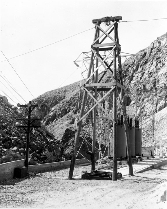
Title: Owens Valley Power Plants and Owens River Gorge
Description: Section of Adams Main Power Plant Subjects: Hills Electrical Apparatus Power Lines Collection: Bledsoe Collection 1908-1933 |
 Barcode:
1000321 |
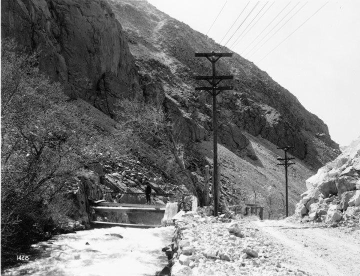
Title: Owens Valley Power Plants and Owens River Gorge
Description: Diversion weir, Adams Auxiliary Power Plant Subjects: Roads Water Hills Power Lines Collection: Bledsoe Collection 1908-1933 |
 Barcode:
1000322 |
Title: Owens Valley Power Plants and Owens River Gorge
Description: Power line from Adams Auxiliary Power Plant Subjects: Hills Roads Power Lines Collection: Bledsoe Collection 1908-1933 |
 Barcode:
1000326 |
Title: Owens Valley Power Plants and Owens River Gorge
Description: Owens River Gorge The Owens River Gorge is a steep 10 miles (16 km) canyon on the upper Owens River in eastern California. The canyon is located at the eastern edge of the Sierra Nevada Mountains in southern Mono County, along the stretch of the river where it exits the Long Valley near its source and enters the north end of Owens Valley. The gorge is a popular destination for rock climbing. The Owens River Gorge was formed when the Owens River cut through the Bishop Tuff: a layer of welded ash formed from the eruption of the long Valley Caldera. This erosion exposed the tuff layers, including rare columnar rhyolite formations. The Los Angeles Department of Water and Power constructed the Long Valley Dam at the head of the Owens River Gorge as part of a hydropower project in 1941, and completely dewatered the 16-km Lower Gorge reach from 1953 to 1991. Beginning in 1991, a limited range of flows has been released to re-water the reach, recreate riparian habitat, and re-establish a brown trout sport fishery while maintaining hydropower diversions. Subjects: Canyons Hills Water Power Lines Collection: Bledsoe Collection 1908-1933 |
 Barcode:
1000327 |
Title: Owens Valley Power Plants and Owens River Gorge
Description: Owens River Gorge The Owens River Gorge is a steep 10 miles (16 km) canyon on the upper Owens River in eastern California. The canyon is located at the eastern edge of the Sierra Nevada Mountains in southern Mono County, along the stretch of the river where it exits the Long Valley near its source and enters the north end of Owens Valley. The gorge is a popular destination for rock climbing. The Owens River Gorge was formed when the Owens River cut through the Bishop Tuff: a layer of welded ash formed from the eruption of the long Valley Caldera. This erosion exposed the tuff layers, including rare columnar rhyolite formations. The Los Angeles Department of Water and Power constructed the Long Valley Dam at the head of the Owens River Gorge as part of a hydropower project in 1941, and completely dewatered the 16-km Lower Gorge reach from 1953 to 1991. Beginning in 1991, a limited range of flows has been released to re-water the reach, recreate riparian habitat, and re-establish a brown trout sport fishery while maintaining hydropower diversions. Subjects: Water Canyons Power Lines Collection: Bledsoe Collection 1908-1933 |
 Barcode:
1000473 |
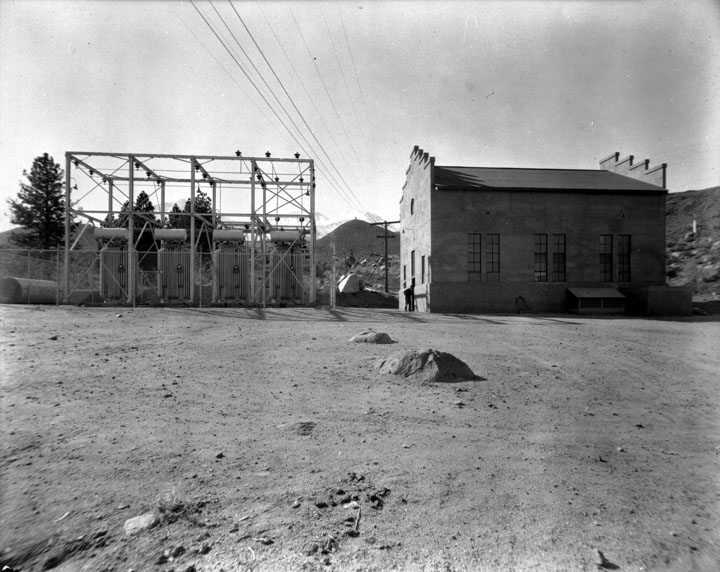
Title: Owens Valley Power Plants
Description: Construction work on Big Pine Power Plant Subjects: Buildings Electrical Apparatus Power Lines Collection: Bledsoe Collection 1908-1933 |
 Barcode:
1000581 |
Title: Scenic Views - Owens Valley
Description: Cloudburst effects in Rose Valley Subjects: Hills Power Lines Utility Poles Collection: Bledsoe Collection 1908-1933 |
 Barcode:
1000613 |
Title: Towns in Owens Valley
Description: Street scene, Bishop California - The first white American explores in the Owens Valley of Eastern California included the famous mountain men Jedediah Smith in 1826 and Joseph Walker in 1834. This remote area of California had never been explored by the Spanish and even though it was shown as Mexican territory on early maps, the Eastern Sierra region remained unvisited by them. Present day Walker Lake in western Nevada, the Walker River on the California /Nevada border and Walker Pass in the southern Sierra were named for their discovered, Joseph Walker. The most renowned early explorer to visit the area was John C. Fremont. He was the first Republican candidate to run for President of the United States in 1856 and later a famous Union Civil War General. Officially sanctioned by the federal government, his 1845 mapping party to the Eastern Sierra included the celebrated Indian scout Kit Carson, for whom the capital of Nevada, Carson City, was named. Also in the party were Ed Kern for whom Kern County, California was named, and Richard Owens, who gave his name to the Owens Lake near Lone Pine and later the Owens Valley itself. Fremont lost a cannon that he had brought along in case of Indian attacks somewhere near present day Bridgeport, California (about 80 miles north of Bishop). Perhaps someone will stumble across the rusty old cannon someday. The city of Bishop came into being due to the need for beef in a booming mining camp some eighty miles to the north, Aurora, Nevada, (Aurora was believed to be on the other side of the border at that time and was the county seat of Mono County, California). In 1861 cattlemen drove herds of cattle some three hundred miles from the great San Joaquin Valley of California, through the southern Sierra at Walker Pass up the Owens Valley, and then through Adobe Meadows to Aurora. Along the way, some cattlemen noticed that the unsettled northern Owens Valley was perfect for raising livestock. To avoid the long journey from the other side of the mountains, a few of them decided to settle in the valley. Driving some 600 head of cattle and 50 horses, Samuel Addison Bishop, his wife, and several hired hands arrived in the Owens Valley on August 22, 1861 from Fort Tejón in the Tehachapi Mountains. Along with Henry Vansickle, Charles Putnam, Allen Van Fleet, and the McGee brothers, Bishop was one of the very first white settlers in the valley. Samuel Bishop made his camp at a location a short distance west and south of the present city of Bishop and later built a house at that location. He named his holdings the “San Francis Ranch.” He was a Virginian born in 1825; a California Forty-Niner judge at Fort Tejón; and partner of General Beale in the cattle business. His residence in Bishop was a comparatively short duration and his closing years were spent in San Jose. Bishop Creek is also named after him. The cattlemen were soon followed by sheep men who initially struggled with a lack of forage for their stock in the area. Remnants of those early settler’s stone corrals and fences can still be seen north of Bishop along Highway 395 in Round Valley (barb wire fencing was not invented until 1873). Subjects: Roads Automobiles Men Buildings Power Lines Collection: Bledsoe Collection 1908-1933 |
 Barcode:
1000615 |
Title: Towns in Owens Valley
Description: Street scene, Bishop, California - The first white American explores in the Owens Valley of Eastern California included the famous mountain men Jedediah Smith in 1826 and Joseph Walker in 1834. This remote area of California had never been explored by the Spanish and even though it was shown as Mexican territory on early maps, the Eastern Sierra region remained unvisited by them. Present day Walker Lake in western Nevada, the Walker River on the California /Nevada border and Walker Pass in the southern Sierra were named for their discovered, Joseph Walker. The most renowned early explorer to visit the area was John C. Fremont. He was the first Republican candidate to run for President of the United States in 1856 and later a famous Union Civil War General. Officially sanctioned by the federal government, his 1845 mapping party to the Eastern Sierra included the celebrated Indian scout Kit Carson, for whom the capital of Nevada, Carson City, was named. Also in the party were Ed Kern for whom Kern County, California was named, and Richard Owens, who gave his name to the Owens Lake near Lone Pine and later the Owens Valley itself. Fremont lost a cannon that he had brought along in case of Indian attacks somewhere near present day Bridgeport, California (about 80 miles north of Bishop). Perhaps someone will stumble across the rusty old cannon someday. The city of Bishop came into being due to the need for beef in a booming mining camp some eighty miles to the north, Aurora, Nevada, (Aurora was believed to be on the other side of the border at that time and was the county seat of Mono County, California). In 1861 cattlemen drove herds of cattle some three hundred miles from the great San Joaquin Valley of California, through the southern Sierra at Walker Pass up the Owens Valley, and then through Adobe Meadows to Aurora. Along the way, some cattlemen noticed that the unsettled northern Owens Valley was perfect for raising livestock. To avoid the long journey from the other side of the mountains, a few of them decided to settle in the valley. Driving some 600 head of cattle and 50 horses, Samuel Addison Bishop, his wife, and several hired hands arrived in the Owens Valley on August 22, 1861 from Fort Tejón in the Tehachapi Mountains. Along with Henry Vansickle, Charles Putnam, Allen Van Fleet, and the McGee brothers, Bishop was one of the very first white settlers in the valley. Samuel Bishop made his camp at a location a short distance west and south of the present city of Bishop and later built a house at that location. He named his holdings the “San Francis Ranch.” He was a Virginian born in 1825; a California Forty-Niner judge at Fort Tejón; and partner of General Beale in the cattle business. His residence in Bishop was a comparatively short duration and his closing years were spent in San Jose. Bishop Creek is also named after him. The cattlemen were soon followed by sheep men who initially struggled with a lack of forage for their stock in the area. Remnants of those early settler’s stone corrals and fences can still be seen north of Bishop along Highway 395 in Round Valley (barb wire fencing was not invented until 1873). Subjects: Roads Buildings Trees Power Lines Collection: Bledsoe Collection 1908-1933 |